An Electronic Chart Display and Information System (ECDIS) is a computer based navigation system used as an alternative to paper navigation charts. Integrating a variety of real time information, it is an automated decision aid, capable of continuously determining a vessel’s position in relation to land, charted objects, navigation aids and unseen hazards.
The ECDIS includes electronic navigational charts (ENC) and integrates information from the Global Positioning System (GPS), speed log, gyro and potentially other navigational sensors, such as e.g. radar, fathometer and automatic identification systems (AIS).
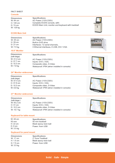
Danelec Marine ECDIS Range
The Danelec Marine ECDIS range is designed based on valuable feedback from ship owners and long time users of ECDIS products. Inspired by customer needs, the innovative Danelec Marine ECDIS range is developed to meet the specific requirements of the maritime industry. By receiving precise information about the position of the ship, the ECDIS can help make navigation easy and significantly improves safety at sea. The system includes intuitive route planning functions, ensuring optimal navigation routes, which in turn can lead to reduced fuel consumption.
► Precise real time positioning and route monitoring including information from interfaced sensors
► Advanced route planning function
► Radar overlay with on screen radar control
► Recording and playback of voyage
► Easy chart update via internet, email or DVD
► Audio and visual alarm functions
► Intuitive menu structure for easy operation with “built-in” user manual and online help